
Introduction
Below I am presenting a first sketch of a proposed flood model. This model includes a number of features that have not previously been accorded full attention, including plate tectonics. It is both preliminary (in the sense that it is new and growing), tentative (in the sense that it is subject to peer review, criticism, revision and/or rejection), and revolutionary (in that it suggests ideas which are new and generally not well tested). At the same time the model appears to cover a broad spectrum of data consistent with observation and revelation, and suggests many tests for its own validation. I am therefore hopeful that it may serve as a starting point for a more comprehensive model. I am greatly indebted to numerous individuals who have contributed substantial ideas to this model, and will acknowledge their debts as they have the opportunity to read and modify what is included here. For now, I accept full responsibility for the representation of their ideas in this preliminary draft.
Rationale
Creationists have long suffered the criticism that they lacked a model to explain the paradigm of earth history they espoused. This criticism has been difficult to shoulder, because it implied that the concept was somehow automatically inferior and less scientific, since no experiments could be devised to test a nonexistent model. Although the same criticism could be applied to the evolutionary "model", the perception that there was a model of any sort proved a significant advantage to evolutionists. An additional tactical advantage was afforded the evolutionists in that their model was largely a description of things the way they were, and thus was consistent with observations of nature by default. Creationists who have generally felt compelled to base their model on Scripture, and to try to fit geological data to the model were thus encumbered with a severe logical and procedural handicap.
The elaboration of a model, even one which may be inadequate to explain every detail, seemed a critical need for Creationists. In this model, I have attempted to be as descriptive as possible, weaving geological observations upon the framework of Scripture. As a result the model is also largely a description of things the way they are, and is thus more naturally consistent with the observed data of science. This proposed model attempts to account for as many features of the fossil record as possible within the framework of constraints provided by the account of Creation and the Genesis Flood. As more information becomes available, the model will be modified accordingly. If the model can be demonstrated not to be of benefit in understanding the past history of the earth, it can be replaced by a better model. In the meantime it offers the opportunities for the kind of rigorous scientific evaluation and testing that should be applied to any model before it is adopted or rejected.
It is my hope that this model offers the opportunity for progress to be made in harmonizing the data from science with the information provided for us in the Scriptures.
The Model
Introduction: The sedimentary layers of rock, and to a lesser extent, all rocks on the earth's surface, contain a record, albeit incomplete and subject to ambiguities, of the processes involved in their formation. This record can be interpreted and a careful and enlightened reading ought to shed light on the processes involved, and open to some extent a window into the past history of the earth. This recorded history of the earth as represented in the rocks (referred to as the "Geologic Record"), may be usefully divided into four major successive intervals.
Precambrian: In many places on the earth's surface, the first deposited rocks contain little or no evidence of life. While these rocks are in other respects similar to the overlying layers, this general lack of fossils, and the basal position of the layers accords them the status of Precambrian. In this discussion such rocks are considered to have been present on the earth prior to the flood.
Paleozoic: Often overlying the Precambrian sediments, but sometimes lying directly on basement, are layers of rock containing abundant fossils of sea dwelling representatives of every major group of animals. While most of these fossil forms are now extinct, they were fully as complex as any equivalent living forms. The rocks containing these fossils are termed Paleozoic in reference to the presumed antiquity of the animals.
Mesozoic: The next sequence of rocks, generally overlying the Paleozoic rocks, but in some cases overlying Precambrian rocks or basement, is termed the Mesozoic. These rocks contain plants and animals of many different varieties, from what might be best described as a mixture of land and marine environments. The plants and animals are almost universally different forms from those in the same phyla present in the Paleozoic record, suggesting a nearly complete replacement of the Paleozoic forms occurred.
Cenozoic: The uppermost sequence of rocks in many areas may overlie Mesozoic rocks, or rocks of any of the other intervals. These rocks contain the fossil remains of land mammals and modern types of land plants, along with a wide variety of other fossil forms, from both extant and extinct groups.
These four terms will be used as defined throughout the remainder of the paper.
The configuration of the original continent on the spinning globe is uncertain. It may have been centered near the South Pole, as paleogeographers suggest, or may have been nearer the equator. Both possibilities have interesting consequences. If the land mass was distributed at the equator, it would probably have a more or less circumglobal distribution. If it was centered on the South Pole, light distribution would present an interesting problem.
This continent exhibited three prominent geographical features. The continent's coastline with the Ocean was bounded by marginal highlands, coastal mountain ranges serving to separate the continental interior from the Ocean. Interior to the marginal highlands, upon the continent itself, lay expansive freshwater seas. Emerging from the seas towards the continental interior, the land coalesced into a broad central plateau.
The central plateau consisted of an extensive, elevated highland, an area now comprising the shield areas of several continents. This plateau was the verdant heart of the planet, containing a seemingly endless variety of plants and animals. The flora of this region was dominated by the angiosperms (flowering plants), and was additionally the habitation of most mammals, including man. The large variety of plants and animals, represented most typically as fossil forms in sedimentary rocks of the Cenozoic, originally inhabited this central plateau. This plateau was dotted with lakes and streams, and served as the foundation for a complex network of waterways. In these central highlands great rivers arose that flowed out to the points of the compass and watered the earth. The rivers were contiguous with the freshwater seas and were circulated by some mechanism, perhaps involving coriolus forces or gravitational drag from a more proximate moon.
Ringing the borders of the continent, marginal highlands separated the land from the Ocean. These marginal highlands were generally more arid than the central plateau, which benefitted differently from the hydrologic system. The more arid marginal highlands were home to a variety of mesic (capable of living with less water) plants and animals dominated by reptilian forms, as well as quantities of sediment destined to end up in Mesozoic deposits.
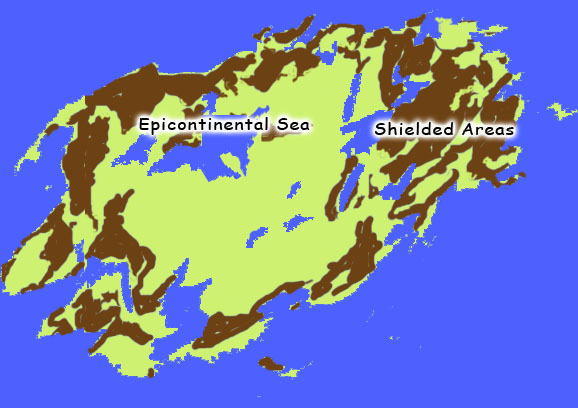
Lying in between the marginal highlands and the central plateau, resting upon the granitic continent itself, were several, perhaps four or more expansive fresh water seas. These water bodies, widely recognized by geologists to have been a prominent feature of the Paleozoic landscape, are termed epicontinental seas. Living within these epicontinental seas were representatives of various groups of vertebrate and invertebrate forms found commonly in Paleozoic rocks.
Extensive vegetation of varied typical Paleozoic flora blanketed the immediate shore and extended out on the surface of the seas in the form of floating islands. Plants included rapidly propagating, mostly herbaceous Paleozoic ground ferns, giant tree ferns, lycopods (extinct relatives of and club mosses) and calamites (extinct forms of the modern horsetails) many times larger than any of their modern relatives. The dominant plants reached heights of over 35 meters with trunk diameters up to a meter or more. The growth of these plants, particularly the arborescent lycopods and calamites, was probably completed in a single season with upward growth rates of 10 - 20 centimeters per day.
The islands, built up from the fallen trunks and leaves of these giant forms, were founded upon the accumulation of tens or hundreds of meters of this humus and plant debris. These islands were inhabited by the types of quadrupeds found in the sedimentary rocks of the Paleozoic, principally amphibia. These several epicontinental seas are represented in the rock record by the geoclines where the extensive deposits of Paleozoic sediments are found today on the continents.
The Ocean itself was a saline body, underlain by basaltic rocks. The waters teemed with fish, whales and other sea creatures representing lifeforms similar to those found in the ocean today as well as many forms now extinct, but generally of types found as fossils beginning in the Mesozoic.
THE FLOOD
At the onset of the flood, rain water accumulated for many days, absorbed into the ground, and flowed down toward the seas. As the flooding continued, the low lying regions adjacent to the epicontinental seas became flooded, and the seas themselves with the animals they contained were increasingly inundated by sediment, perhaps aided by the release of water and sediment from rupturing of the hydrologic system. The patterns of paleocurrents observed in the Paleozoic largely reflect these basinward trends, generally heading across and along geoclinal axes.
As the sediments accumulated in the seas, changing salinity (due perhaps to increasing volcanic activity, or the unroofing of salt deposits), increasing turbidity (due to the transport of volumes of sediment into the water) and/or temperature changes (due to the occlusion of the sun for many days), resulted in the precise and successive destruction of various life forms in the water column, as their limits of toleration were reached. These forms would then have been buried in an orderly and successive manner in each of the geosynclinal basins where they formerly resided. At the water surface, the floating islands of vegetation, fragmented by the storm, were translocated by the shifting tidal currents to shoaling environments where the water-saturated masses became embedded in silt and emplaced. Continually rising waters, driven by tidal currents, repeated this cycle, bringing and burying additional layers of the amassed vegetation of the epicontinental seas and giving rise to the great coal measures of the Carboniferous.
The global temperature declined under the influence of continuous cloud cover. In the central plateau, snow and ice began to accumulate, forming massive ice caps which encompassed the upland floras and faunas of the central plateau. As these ice sheets moved across the plateau, the earth was scoured to bedrock. Here expansive regions of the continental interior were stripped of all sediment. As a consequence, the central plateau, a region later to become the shields of Africa, South America, North America, and other continents, was exposed. Glacially derived sediments made significant contributions to the flooded continental borderlands below.
The end of the Paleozoic and the beginning of Mesozoic was signaled by the breaching of the coastal margins by the rising saline waters of the Ocean. During the Paleozoic, these waters were restrained by the marginal highlands. But now, under the influence of continuing rain and a subsiding continent, the waters spilled into the interior, carrying with them volumes of sediment and biota from the coastal highlands. These waters spread across the now filled basins of the epicontinental seas, blanketing the continent with additional sediment, and destroying the last vestiges of salt-intolerant Paleozoic life forms in a massive extinction. These life groups were quickly replaced by organisms from the saline marine Oceanic fauna, and from the mesic life zones of the marginal highlands including dinosaurs and other reptilian forms. Coral reefs with entirely new faunas and other sessile Mesozoic life forms were either accreted from the near shore environment of the Ocean to the continental margins as the expanding continents overrode the seafloor, or were buried along the continental margins by sediments washed down from the coastal highlands, or were transported basinward by catastrophic processes.
For days or weeks the shallow regions continued to sustain life for some terrestrial groups, and the surviving land animals migrated to higher ground. Under the relentless onslaught of continually rising water, even these forms were soon in jeopardy. Continued erosion of the marginal highlands fed sediments both into the continental interior and to offshore deposits soon to be accreted to the advancing continental margins.
The entire continent is now threatened with inundation. Powerful marine currents rush across the submerged landforms, distributing sediment and organisms across the continents, and overtaking and drowning whole groups of surviving land creatures. These Mesozoic currents are distinctive from the Paleozoic currents, in that the latter are manifestly related to the epicontinental seas, generally directed outwardly across the continents. The Mesozoic currents are more often unrelated to basins, being dominated by flow toward the continental interior, and are generally directed toward the continental interior from the borderlands. The advancing marine waters convert the earth's surface into one vast unbroken expanse of water, as they gradually cover even the highest points of land. The remains of decaying vegetation and animal carcasses litter the ocean surface.
Toward the end of the Mesozoic, the great continental breakup begins. Continental paleocurrents indicate a trend toward the newly opening basins of the proto-Atlantic in the interior of what used to be Pangea. The continents begin to isostatically rise, and associated volcanism generates great quantities of ash and lava. The heat lost due to solar occlusion is replaced by heat released from magma erupted during continental rifting, and the massive ice floes melt, depositing the remains of plants and animals of the central plateau near the earth's surface. The continents emerge from the floodwaters, cutting off basins with the contained water and plant and animal debris. These basins themselves begin to accumulate sediment, and debris sinks and is buried in the sediment as the catastrophic processes abate. But now the dominant paleocurrent patterns are basinal, with substantial contributions from the developing major continental drainages such as the Mississippi embayment.
The receding waters in the late Cenozoic carve out canyons as they drain the uplifting continents, carrying huge volumes of sediment into the modern ocean basins as the familiar continental forms emerge, accompanied by mountain building and continental faulting and folding on a grand scale. Outwash and continued anastrophic (localized catastrophic) processes result in the scouring off of large areas of the continents and sedimentary burial of stranded flood debris. Floating carcasses of birds and mammals decay, dropping a rain of debris into the accumulating sediment. Plants began to resprout, some of the surviving fish multiplied in the lakes, and insect populations burgeoned.
THE RECOVERY
For a period of time following the end of the general catastrophe, the earth continues to recover from its effects. Rainfall continues at exaggerated rates, the climate oscillates between ice-age generating cold and glacial retreating heat, the earth itself continues to shudder from these influences. Finding the presence of an open environment, the animals rapidly radiate across the land. Reproductive rates are optimal. The availability of open niches everywhere encourages speciation at unprecedented rates. Gradually the climatic fluctuations become less evident, and the earth settles down to a less catastrophic period.
EXPLANATIONS AND TESTS OF THE MODEL
This model is directly based on a number of observations with respect to the earth's past history. I will attempt to detail these below in the context of their significance to the model.
Modern Oceanic Basins: The basins of modern oceans appear to contain no sediment anywhere that is older than Mesozoic. That is, sediments recovered from the ocean floor today do not contain fossils of the types found in Paleozoic rocks. This has led Plate Tectonics theoretists and paleogeographers to assume the entire ocean floor of the Paleozoic ocean has been subducted, conveniently removing what should have been a major problem for the evolutionary model. The model presented here, by contrast, offers an explanation for the absence of Paleozoic fossils in the ocean basins without having to resort to a complete replacement of the ocean floor. This becomes important in light of the thermal consequences of plate motion. When ocean floor is subducted on one side of a continent, it must be regenerated on the other side of the continent. This regeneration may involve the continent overriding the ocean floor, or the expulsion of massive quantities of molten magma into the ocean floor. In either case, the process is considered to involve the production of heat or molten rock. This molten rock would considerably alter the heat balance of the ocean
This model also explains what has been a great difficulty for conventional geologists. Nearly all of the sediment in the modern ocean basins is from the uppermost Cenozoic (about 95% is Miocene-Pliocene). Before this there is little record of continentally derived sediment on the ocean floor. While I have not heard a convincing explanation for this data within the evolutionary paradigm, it fits perfectly a model with the present continents final emergence from the flood waters in upper Cenozoic, with massive continental runoff continuing through the Cenozoic to the present.
Predictions and Tests of the Model: A great deal more work remains to be done before this model is ready to present publicly. The following are some of the areas of intense interest which need serious exploration:
Patterns of Geoclines: A series of depositional basins cut across most of the major continents, and serve as the repositories of most of the Paleozoic sediments. These "Marginal Basins" or geoclines represent the remnants of the preflood epicontinental seas. The patterns they form on the earth's surface provide important information about the precise arrangements of the preflood continents and the water systems. Information is readily available indicating where on the various continents these geoclines lay. This is greatly aiding our attempts to reconstruct the pre-flood geography, placing the seas, and giving us a handle on where the source areas for Mesozoic and Cenozoic plant and animal life and sediment might be.
Marginal Highlands: We are accumulating more information on the type of rocks present in the marginal belts (often called "Mobile Belts") which bounded the continents, and delimited the epicontinental seas from the Ocean. These mountains should represent the kinds of rock found on the seafloor, and should be unfossiliferous or, if fossiliferous, contain Mesozoic types of fossils. This appears to be the case at present.
Paleocurrents: Paleocurrent patterns are providing key information about the movement of water and sediment on the North American continent through time. We are accumulating similar types of data from the other continents, so that reconstructive work can be done there as well. This is crucial for reconstructing the form of the original supercontinent. Based on current data, it appears likely that during the Paleozoic, essentially all flow was away from the central highlands, as the model predicts, and that the direction of flow during Mesozoic was contrary to this, again as the model predicts. In the Cenozoic, basinal currents appear to be the rule, again as the model predicts.
Reconstruction of Protopangea: We are seeking to understand the paleomagnetic data better in order to determine what "latitude" we have for positioning the continents that are not usually considered a part of the proto-Pangean supercontinent of the early Paleozoic. North America (Laurentia), Europe and Asia (Laurasia), and Russia (Siberia) are often depicted as roaming around the planet for much of the Paleozoic, while the Gondwanan supercontinent remains more or less intact. At present it appears the data for paleogeographic reconstructions are very accommodating. The idea of maintaining a single Paleozoic supercontinent seems not too farfetched, since longitude cannot be derived from paleomagnetic data. Thus the land masses can more or less be positioned anywhere in longitude. Latitude is also often determined by inferential data other than paleomagnetism, even in preference to paleomagnetic data.
Coral Reefs: The model explains the presence of Paleozoic corals on the continents. It also predicts the general absence of Mesozoic and younger corals on the continents. The prediction of the model that post-Paleozoic corals (corals, because unlike other marine forms these cannot swim, walk or fly, and grow rather slowly) should be found in proximity to the margins of the Ocean, or must be derived from that margin by some sedimentological or tectonic process appears to hold. Major Scleractinian and other Mesozoic and younger bioherms (reefs composed of the remains of living creatures) are with few exceptions found along continental margins, or in collision zones (former continental margins).
As a corollary, the model predicts that the suture zones from continental collisions should contain Mesozoic ocean floor sediments, and Mesozoic coral reefs, (i.e. Scleractinian corals, etc.). An analysis of the kinds of fossils found in the Pyrenees, the Alps, the Himalayas, the Carpathians, the Urals and other putative collision zones should contain sediments from the Ocean floor. This holds for the Alps, and for other such zones that have been evaluated.
Accreted Terrane: Significant areas of several continents are considered to have been accreted to the continental margins as the continental plate overrode the oceanic plate. Sometimes these accreted or "exotic" terranes are of oceanic origin, and should have fossils of Mesozoic or younger types, and sometimes they represent fragments of other continents accreted by collision, in which case the remnants of a marginal basin may be included, with principally Paleozoic fossils. We are testing the hypothesis that, in general, accreted terrane of continental origin will contain fossils of Paleozoic types, whereas accreted terrane with Mesozoic or younger fossils will be oceanic in origin. Accreted terrane of oceanic origin with Mesozoic coral reefs would be consistent with the model. From the perspective of over 200 identified terranes in North America, and 20 or more each from South America and New Zealand, described terranes are overwhelmingly consistent with the model. The handful of exceptions have not been analyzed in detail yet to see if they can be accommodated by the model.
Marine Microfossils: Radiolaria are found in both the Paleozoic seas and in the Meso-Cenozoic deposits. Today radiolaria are only known from salt water environments. The assumption is made therefore that in the past radiolaria were only marine. There are numerous deposits of Paleozoic rocks containing radiolarian cherts. However, the Paleozoic forms were almost entirely eliminated by the end of the Paleozoic, as would be expected were fresh water forms to be exposed to saline conditions. Some substantial data for the existence of fresh water radiolaria needs to be sought. Certain other planktonic and benthonic microfossils may be found in both fresh water and saline environments, but the exact forms should differ.
Mesozoic Sedimentation: The distribution of Mesozoic sediments should extend well beyond the margins of the Paleozoic epicontinental seas. The Mesozoic patterns should reflect the different sources of sediment as well as the inward flow toward the central plateau. This appears to be true on those continents where sufficient data is available, and more data is being obtained. The model predicts that additional data from other continents will reflect this trend.
Taphonomic Research: The model also suggests a fruitful area for experimentation in taphonomy. Environments containing complex biota could be subjected to changes in salinity, temperature and/or turbidity to determine whether orderly death can be modeled to explain the sequence in the fossil record.
CONCLUSIONS
Creationists have long suffered the criticism that they lacked a model to explain the paradigm of earth history they espoused. This criticism has been difficult to shoulder, because it implied that the concept was somehow automatically inferior and less scientific, since no experiments could be devised to test a nonexistent model. Although the same criticism could be applied to the evolutionary "model", the perception that there was a model of any sort proved a significant advantage to evolutionists. An additional tactical advantage was afforded the evolutionists in that their model was largely a description of things the way they were, and thus was consistent with observations of nature by default. Creationists who have generally felt compelled to base their model on Scripture, and to try to fit geological data to the model were thus encumbered with a severe logical and procedural handicap.
The elaboration of a model, even one which may be inadequate to explain every detail, seemed a critical need for Creationists. In this model, I have attempted to be as descriptive as possible, weaving geological observations upon the framework of Scripture. As a result the model is also largely a description of things the way they are, and is thus more naturally consistent with the observed data of science. This proposed model attempts to account for as many features of the fossil record as possible within the framework of constraints provided by the account of Creation and the Genesis Flood. As more information becomes available, the model will be modified accordingly. If the model can be demonstrated not to be of benefit in understanding the past history of the earth, it can be replaced by a better model. In the meantime it offers the opportunities for the kind of rigorous scientific evaluation and testing that should be applied to any model before it is adopted or rejected.
It is my hope that this model offers the opportunity for progress to be made in harmonizing the data from science with the information provided for us in the Scriptures.
Note 1 - Plate Tectonics, the theory that the continents ride on lithospheric plates and have been moving around on the surface of the earth throughout geologic time.
Note 2 - Basement refers to the "original" granitic or metamorphic rocks comprising the present day continental plate, in contrast to, for example, other sedimentary rock, etc. which in turn would then itself lie on the basement.
Note 3 - Paleomagnetism is evidence of the earth's past magnetic pole, preserved in igneous (once molten, such as lava, etc.) rocks, or in sedimentary rocks. The assumption is made that the imprint of the earth's magnetic field is preserved in the form of magnetic dipoles (usually crystals of iron oxide, or magnetite, oriented to the earth's magnetic field) in sedimentary or igneous rock, and that these dipoles indicate the magnetic field lines on the earth's surface at the time the igneous rock was solidified, or the sedimentary rock was deposited. Using sensitive magnetometers, these ancient poles can be reconstructed from measurements on carefully oriented rock cores, and the direction and distance to the ancient pole can be determined. Assuming for now that the work was done accurately, and the interpretation is correct, one can map, through time, the direction these measurements suggest North to be, and the distance to the North Pole. From these data, one can reconstruct a location and orientation for any particular continent, based on the magnetic poles of the rocks deposited on that continent during the interval in question. It is generally assumed that the earth's magnetic pole itself has not moved far from its present position, although that assumption is not easily verified.
Note 4 - Paleogeography is the science devoted to attempting to reconstruct the geography of the earth's surface and the location of its continents etc., throughout its past history, primarily from the evidence contained in the rock record.
Note 5 - For example, see the latest paleogeographical reconstructions available on the internet. Such an interpretation is also consistent with Genesis 1:9, and insofar as I am aware is not contradicted by any physical data. Like all modern continents, the Great Continent rode on a granitic base. Granite (SIAL--SIlicon and ALuminum rich rock) is light and floats high on the mantle, acting as a foundation for the continents. Basalt, (SIMA--Silicon- and Magnesium-rich rock) is dense and sinks in the mantle, thus underlies the ocean basins of all oceans today, as well as the basin of the Ocean.
Note 6 - Among "other reasons" was a significantly higher concentration of carbon dioxide in the atmosphere, perhaps as high as 10 to 100 times the current level of 0.03 percent. While the existence of water above the firmament, in whatever form, the so-called "canopy", is directly relevant here, a consideration of it has for the present been sidestepped in order to avoid the prejudice this concept engenders.
Note 7 - Regions of Precambrian basement rocks (granitic and metamorphic rocks) stripped of all sediment. Such shields are present in central Africa, in northern North America, in western South America, Australia, and elsewhere.
Note 8 - The nature of the hydrologic cycle prior to the onset of rain is speculative. The circulation of water may have involved a diurnal process such as gravitational influence of the moon. If the moon were closer to the earth in the Paleozoic as is postulated by some geologists, and suggested by inspiration, lunar tides may have been strong enough to have forced a periodic rise in the water table, expelling moisture-laden air from the soil which would have condensed to form a mist, and bringing water to within reach of the roots of plants. The same principle is involved in substrate hydroponics, where the periodic moistening of the substrate (generally a rock aggregate), by raising and lowering the water table, appears to provide ideal conditions for plant growth.
Note 9 - Such marginal mobile belt mountains are a prominent feature of advancing continental margins of mobile plates, resulting from the compressive forces associated with overriding oceanic plates. They are present, for example on what would have been the exposed (compressional) margins of the Gondwanan supercontinent, but are found on none of the extensional margins of continents resulting from the breakup of the supercontinent, such as the Atlantic seaboards of Africa and South America.
Note 10 - The choice of fresh water over salt runs contrary to conventional wisdom, but there are some compelling reasons for making the assumption ... for example this one assumption can explain why nearly all Paleozoic marine forms are extinct, since, in this model, the sudden conversion of the epicontinental seas to salt water at the onset of the Mesozoic (see below), would doom most Paleozoic forms. There is good reason to think that the dominant quadrupeds (amphibians), and the plant forms of the Paleozoic could not have survived in salt water, since the extant forms of both groups cannot tolerate salinity. The concept of freshwater epicontinental seas is a useful, but not at this point, a necessary one. Interestingly, the Babylonian creation account (Pritchard, Ancient Near Eastern Texts), which, like the Babylonian flood account, appears to preserve certain remembrances of a great original event, plays off the creation as a battle between two primeval seas, one salt water , the other fresh water. With respect to certain groups of Paleozoic fish, Romer has stated "The early members of the group were, in general, fresh-water types" (Alfred S. Romer, Vertebrate Paleontology, (Chicago U, 1945), p. 121
Note 11 - These epicontinental seas have long been postulated by geologists to explain the presence of marine sorts of animals in the continental fossil record. It is significant and consistent with the model that these great epicontinental seas are a dominant Paleozoic feature.
Note 12 - Animal life forms of the Paleozoic are overwhelmingly marine, here taken to mean water dwelling.
Note 13 - These floating islands have an interesting analogue in the modern environment, where the only surviving relatives of the Paleozoic plant species produce quaking bogs floating on the surface of water bodies. In addition, numerous features of the Paleozoic plants, such as arenchymatous roots as in Psaronius, or blunt, pencil-sized rootlets spiraling from a large cylindrical axis with a terminal bud as in Lepidodendron and other genera, make it clear that these giant dominant forms could only have grown in such an environment, or at least, could not have grown in soil. An encrusting marine worm found commonly preserved with these plant fossils, comes from a family that is found today only in fresh water.
Note 14 - On these floating islands various Paleozoic reptilian and amphibian forms lived. These animals are sometimes found as fossils associated with the remains of this vegetation, such as in the hollow trunks of lycopods. Modern amphibia cannot tolerate salt water (with the possible exception of one modern species of toad that inhabits tidal flats), and there appears to be no basis for the assumption that their Paleozoic progenitors were any different.
Note 15 - The absence of expected Paleozoic sediments in the ocean basins has been a universal disappointment to geologists. While Plate Tectonics provided a mechanism for sweeping the problem under the carpet, this has not proved a very satisfying solution. Why is there no evidence anywhere of Paleozoic sediments in the modern ocean basins? See below on exotic terranes.
Note 16 - These latter may have included sediments associated with the filtration system of the pre-flood aquifers.
Note 17 - Salt (NaCl) is released in great quantities during volcanic eruptions. Some authors have suggested Paleozoic salt deposits are of this origin. Modern geothermal salt deposits of the Mediterranean seafloor associated with rift zones are apparently of this origin as well.
Note 18 - The name used in Europe and Great Britain, etc., and elsewhere in a general sense, to represent much of the upper Paleozoic. These deposits typically are characterized by the presence of significant quantities of coal.
Note 19 - According to Niles Eldridge, and others, the Great Permian Extinction resulted primarily from an increase in salinity, coupled with changing temperatures. While his analysis is based upon different criteria, it is significant that both models concur on this point.
Note 20 - Romer continues with respect to the fish groups mentioned earlier, "... in the Triassic, when coelacanths were common and varied, we find them in marine [here, salt water, as opposed to the freshwater Paleozoic forms] deposits. The group survived in this new environment...." Ibid.
Note 21 - i.e. the basaltic ocean floor (denser) has been overrun by the moving granitic continental plates (lighter), and the ocean floor has been consequently shoved down under the continents, into the mantle, to be assimilated by the mantle or recycled.
Note 22 - This term denotes the concept of a geologic record representing long ages and gradual accumulation of rock layers, as well as the concept of a fossil record of progressive change through time from molecules to man.
Note 23 - The suggestion has been made that excess heat would quickly boil the oceans dry if we are dealing with a diluvial time scale. This argument has been used against Creationists as an ancillary problem to radiometric dating...both indicate 6000 years to be embarrassingly short. However, if the ocean basins were not completely regenerated in the Paleozoic, but instead, we had a single episode of plate movement at a late stage of the flood, and perhaps to a lesser extent for some time after the flood, as this model suggests, then heat dissipation might become a manageable problem. For example, a number of different calculations of the amount of thermal flux received by the earth from solar radiation yield a figure of 1024 calories per year. Given a specific heat of 1 (relative to water at 4) and an average density of 3.2 g/cc for basalt, a loss of this energy due to a marked increase in the albedo (which even at present can reflect over 95% of the incident radiation), could enable the earth to maintain its present temperature while absorbing the heat of 1 million cubic kilometers of basalt cooled by 100 degrees in one year from this source alone. Adding to this the great advantage afforded cooling by the hydrologic cycling from the subaqueous magma and black body radiation, and there should be a reasonable outlet for the post-Cretaceous seafloor heat within a short time frame.
Note 24 - Taphonomy is the study of the death and burial conditions of animals (and plants).
Note 25 - The most glaring omission is any significant consideration of the data from radiometric techniques. This omission is deliberate. I believe it is essential for all readers to be aware that the time frame proposed in this paper is inconsistent with conventional interpretation of radiometric dates. Some may consider this omission grounds for rejecting the model without due consideration. While I sympathize with such an attitude, I think it is short-sighted. Radiometric dates, whatever their ultimate meaning may be, are only one class of evidence. Personally, I prefer to reserve judgment on their meaning because of the clear inconsistency between the presently accepted meaning of such dates and the unambiguous testimony of the Word of God. It is my hope that others will rigorously study this issue and seek a resolution within the paradigm.