Colin W. Mitchell (Clique para currículo completo)
Geomorfologia, Geografia e Geologia de Solos
Interesses Gerais
Os interesses de Colin Mitchell incluem caracterização de solos, e análises da origem de caracteristicas geomórficas e paisagems.
Pesquisa atual
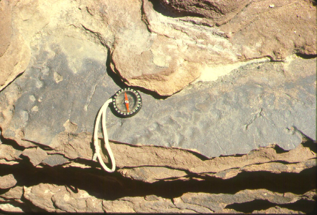
Mitchell está atualmente fazendo consultoria, ensinando filosofia em Newbold College, e conduzindo pesquisas no Jurassic Great Dirt Bed na Inglaterra.
|
||
Publicações Selecionadas
Books
1985 with J A Howard: Phytogeomorphology, John Wiley & Sons, New York.
1986 (reprinted 1991) with R D Thompson, A M Mannion M Parry, and J R G Townshend: Processes in Physical Geography, Longmans, London.
1991 Terrain Evaluation, Longmans , London, 2nd edition, 1991.
1994 The Case for Creationism, Stanborough Press, Grantham Lincs.
1995 The Remote Sensing Society: The Early Years 1974-1995, Remote Sensing Society, Department of Geography, University of Nottingham.
Journal articles and reports
1972-1973 Editor: Studies on the Geomorphology and Agriculture of the Northern Sahara 1972-3, Geography Department, Reading University.
1973 Soil classification with particular reference to the Seventh Approximation, Journal of Soil Science, 24 (4), 411-420.
1973 The Application of ERTS-1 Imagery to the Sudan Savanna Project, Remote Sensing Centre, FAO, Rome.
1974 with S G Willimott: Dayas of the Moroccan Sahara and other arid regions, Geographical Journal, 140 (3), 441-453.
1974 with D M Clark and J A Varley: Geomorphic evolution of sediment-filled solution hollows in some arid regions (NW Sahara), Zeitschrift für Geomorphologie, Supplementband 20, 130-139.
1977 Interpretation of photos. Nos 5:6, 5:7 & 5:8 (pp 78-83), in Perrin, R M S, Air photography in soil science. In St Joseph, The Uses of Air Photography, 2nd edition, John Baker, London, 66-85.
1978 The use of Landsat imagery in a land system classification of Jordan, Journal of the British Interplanetary Society, 31 (8), 283-292
1978 with J A Howard: The Application of Landsat Imagery to Soil Degradation Mapping at 1:1,000,000, FAO Series AGLT 4/78, Rome.
1979 Terrain evaluation, chapter 8 in Goodall, B and Kirby, A (eds) Resources and Planning, Pergamon International Library, Oxford.
1979 with Webster, R, Beckett, P H T, and Clifford, B: An analysis of terrain classification for long-range prediction of conditions in deserts, Geographical Journal, 145 (1), 72-85.
1980 with J A Howard: Phytogeomorphological classification of the landscape, Geoforum, 11, 85-106.
1980 with Gavish, D: Land on which battles are lost and won, Geographical Magazine, L11 (12), 838-840.
1981 Reconnaissance land resources surveys in arid and semi-arid lands. Chapter 8 in Townshend, J R G (ed) Terrain Analysis and Remote Sensing, George Allen & Unwin, London, 169-183.
1981 Soil degradation mapping from Landsat imagery in North Africa and the Middle East. In Allan, J A, and Bradshaw, M (eds), Geological and Terrain Analysis Studies by Remote Sensing, Remote Sensing Society, Reading.
1982 with Howard, J A and Mainguet, M M: Soil Degradation Mapping from Landsat in North Africa and the Middle East. In First Thematic Conference: Remote Sensing of Arid and Semi-arid Lands, Environment Research Institute of Michigan (ERIM), Cairo, Egypt, 899-908.
1982 with Travaglia, C: Applications of Satellite Remote Sensing for Land and Water Resources Appraisal, People's Democratic Republic of Yemen (PDRY), FAO Report Remote Sensing Series 9, TCP/PDY/0104 (Mi), Rome.
1983 The soils of the Sahara with particular reference to the Maghreb, Maghreb Review, January-April, 8 (1-2), 29-37.
1984 Soils, chapter 4 in Cloudesley-Thompson, J L (ed) Sahara Desert, Key Environments Series, Pergamon Press, Oxford, 41-56.
1985 Landsat-based land system survey in northern Iraq, Proceedings of the First National Symposium on Remote Sensing, Baghdad, Iraq, 26-28/10/85, Vol 2. Space and Astronomy Research Centre, Baghdad.
1987 with Roberts, C: Spring mounds in southern Tunisia, in Frostick, L E and Reid, I, Desert Sediments Ancient and Modern, Geological Society of London Special Publication No 35, Blackwell, Oxford, 321-334.
1987 Trends and needs in remote sensing for land applications, in Advances in Digital Image Processing, Proceedings of the Annual Conference of the Remote Sensing Society, Nottingham, 145-153.
1987 Terrain evaluation, in Bell, F G, Ground Engineer's Reference Book, Butterworth, London, 23/1-23/8.
1988 Xizang (Tibet), Contemporary Review, Vol 252 (1468), 269-270.
1988 An international approach to GIS based on remote sensing and terrain classification. In IGARSS'88 (1988 International Geoscience and Remote Sensing Symposium), Edinburgh: Remote Sensing: Moving Towards the 21st Century, European Space Agency, Paris 117-118.
1991 Physiography, geology, and soils, in Craig G M (ed.) The Agriculture of the Sudan, Oxford University Press, Oxford, chapter 1, 1-18.
1995 The Remote Sensing Society: a history 1993-1995. In Curran, P J & Robertson, Y C (Compilers) RSS95 Remote Sensing in Action, Proceedings of the 21st Annual Conference of the Remote Sensing Society 11-14 September 1995, University of Southampton, 179-186.
Reviews and Notes
1972 Glennie K W (1970) Desert Sedimentary Environments, in Geological Magazine 109 (2) 182-183.
1973 White D (ed.) (1972) Resource Satellites and Remote airborne sensing for Canada, Proceedings of First Canadian Symposium on Remote Sensing, Ottawa, February, in Photogrammetric Record.
1973 Potter J S, Wetherby KG & Chittleborough D J (1973) A Description of the Land in County Albert, County Alfred and Part of County Eyre, South Australia, and also Chittleborough D J and Wright M (1973) Murray New Town Selection; A Preliminary Soil and Landform Study, in Photogrammetric Record.
1974 Muller S V (1971) A System for Describing and Classifying Information concerning Landforms, in Regional Studies.
1974 Amiran D H K and Wilson A W (eds.) Coastal Deserts: Their Natural and Human Environments, in Regional Studies.
1976 Frederick K D (1975) Water Management and Agricultural Development: A Case Study of the Cuyo Region of Argentina, in Journal of Peasant Studies 3 (4) 496-497.
1977 Worthington E B (ed.) (1977) Arid Land Irrigation in Developing Countries: Environmental Problems and Effects, in Regional Studies Review 11 (6).
1978 Young A (1976) Tropical Soils and Soil Survey, in Progress in Physical Geography 2 (1) 176-178.
1979 Maass A and Anderson R L (1978) ...And the Desert Shall Rejoice: Conflict, Growth, and Justice in Arid Environments, in Regional Studies 13 (4).
1979 Kowal L M and Kassam A H (1978) Agricultural Ecology of Savanna: Study of West Africa, in Geographical Journal 145, 478-479.
1984 Division of Soils CSIRO (1983) Soils: an Australian Viewpoint, in Journal of Arid Environments.
1985 El-Baz F (ed.) (1984) Deserts and Arid Lands, in International Journal of Remote Sensing, 6 (1) 263.
1994 Raschke E Stuhlmann R Palz W and Steemers T C (1991) A A Balkema Rotterdam.Solar Radiation Atlas of Africa: Global and Diffuse Radiation Fluxes at Ground Level Derived from Imaging Data of the Geostationary Satellite Meteosat 2, in International Journal of Remote Sensing.